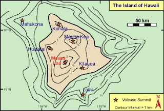

Above are two topographic maps of the Big Island of Hawaii. The first (top) map uses contour lines with an interval of 1 km to show the elevation and shape of the land, and labels all of the volcano summits on the island. The second (lower) map only labels the two volcano summits of Mauna Loa and Mauna Kea, and uses a slightly smaller scale to detail and show the elevation and shape of the land. Though the first map is easier to understand visually because of its use of labels and symbols, the second map provides a better visual representation of the actual shape and contour of the Island.
No comments:
Post a Comment