A Cartographical World
Sunday, December 5, 2010
Isopleths
http://www.globalchange.umich.edu/globalchange1/current/lectures/kling/water_nitro/water_and_nitrogen_cycles.htm
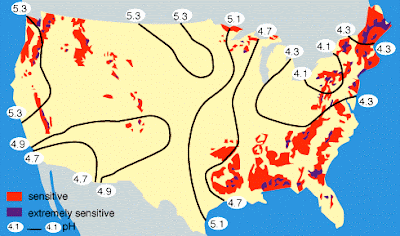
Isopleth maps generalize and simplify data with a continuous distribution. They show the data as a third dimension on a map. For example, the contour lines on this map show the pH of precipitation across the United States.
No comments:
Post a Comment
Newer Post
Older Post
Home
Subscribe to:
Post Comments (Atom)
No comments:
Post a Comment